Detailed description of work plan of the project
Research approach
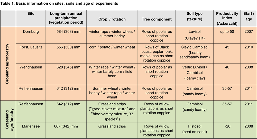
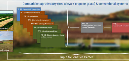
In our research alliance we plan to compare existing experimental agroforestry systems in Germany with adjacent conventional agricultural systems. The agroforestry systems that we will evaluate were established between 2007 and 2011 (Table 1) and a lot of site-specific information has been collected since establishment, however, the individual agroforestry experiments have been used to answer different questions using a wide variety of methods. In Bonares-SIGNAL we plan a coordinated approach, in which we will conduct a systematic comparison of these unique experimental sites using a uniform methodology. Apart from productivity, profitability and social/societal acceptance we will evaluate these land use systems for nitrogen (N), phosphorus (P), potassium (K), Calcium (Ca) and Mag-nesium (Mg) response efficiencies and water use efficiencies and their link to rhizosphere and soil biological processes. Since interactions between the soil biological community, rhizosphere, nutrient cycling, water use and plant productivity are complex they can only be evaluated when measurements are combined using a modeling approach. Our endeavour is only possible with inputs from different disciplines and we have organized the BonaRes-SIGNAL research alliance accordingly. Our research sites include five existing long-term alley cropping agroforestry experiments (arable crops with strips of fast growing trees) in Germany covering a gradient of soil and climatic conditions. Furthermore, we include two grassland sites, both consisting of grassland with strips of fast growing trees. See for details Table 1.
Core design
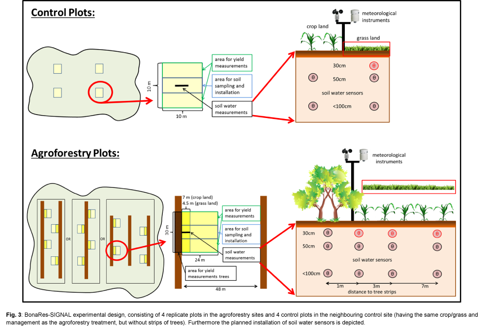
All sites (Table 1) have in common that they consist of strips of fast growing trees either with arable crops or grassland. Strips of fast growing trees create variability in the performance of trees and of cropland and grassland. It has been shown in earlier studies that close to the transition from trees to crops/grassland competition for resources is highest while further away crops/grassland may benefit from the presences of the tree strips. This is why the distance from the tree strips plays a central role in our core design. The distance between strips varies, but most agroforestry-cropland sites include a treatment of 48m between tree strips (with the exception of Reiffenhausen where the distance between the strips is 12m). In the agroforestry-grassland sites the distance between tree strips is 48m for Mariensee while in Reiffenhausen the distance between tree strips is 9m. Within BonaRes-SIGNAL we have agreed on a common design (Fig. 3). This design consists of 4 replicate plots; in case of agroforestry-cropland 30m long, with width varying from 24m to 12m (Reiffenhausen only); in case of agroforestry-grassland 24m long, with width varying from 24m (Mariensee) to 4.5m (Reiffenhausen) and 4 control plots (10m x 10m) in the neighbouring control site (having the same crop/grass and management as the agroforestry treatment, but without strips of trees). Using these core plots, we will be able to investigate the effects of tree strips on soil processes and biomass production by sampling at multiple distances from the transition of trees to arable crops/grassland to the middle of the strips with arable crops/grasslands. In all agroforestry-cropland sites we will select poplar (clone mix „Max“) as fast growing trees, while in the agroforestry-grassland sites we will select willow (different genotypes). Replicate plots will be allocated using a stratified random procedure. We are aware that we will not be able to investigate all possible factors using our common design in the first three years; however, based on the results from the first phase we plan to adjust the common design in the second phase to study additional factors.
Central services
We plan to conduct detailed soil hydrological and meteorological measurements at each site on one replicate plot both in agroforest and in the control. Soil water sensors will be installed as part of the central services by TP1 following the design that we agreed upon (Fig. 3, at some sites soil depth is less than a meter and the depth at which sensors will be installed will be adapted accordingly). In this design we will measure soil water content at different distances to the tree strips, which will yield information on how tree strips affect soil water content (e.g. through uptake by roots or changes in wind speed).
As part of the central services we will also conduct a soil sampling during establishment of the core plots at all sites. Soil samples for analysis of soil chemical and soil physical properties will be taken at each replicate plot; at fixed distances from the transition of tree strips to arable crops/grassland in the agroforestry plots and from fixed sampling points in the controls. Locations for soil sampling in the agroforestry sites will be: one sample in the tree strips and samples at the following distances from the tree strips: 1, 3, 7 and 24m (or the middle of the strip of arable crops / grassland strips). At each replicate plot and each distance to the tree – crop/grassland transition we will take 8 subsamples which will be pooled in a composite sample for analysis. Soil samples will be taken at predefined depth intervals (0-0.30m, 0.30-0.60m). Soil samples for bulk density measurements will be sampled from the soil pits that will be temporally established during installation of the soil moisture sensors.
All subprojects that will sample for soil biological properties and for biomass estimates will also follow a similar design at fixed distances from the transition of the tree strips to arable crops/grassland.
Plans for the second and third phase
Based on the results of the first phase (3 years: 01.06.2015 – 31.05.2018) we intend to continue with BonaRes-SIGNAL in a second and third funding phase (up to six years). In the second phase we in-tend (1) to add other variables to our core design that are not covered during the first phase due to resource limitations; (2) to use the improved and calibrated models to make knowledge-based prognosis of functional processes in soils and locations other than our present sites and to extrapolate results to larger areas and communicate this to stakeholders; and (3) to contribute our knowledge to the development of the web-based portal for sustainable soil management decisions.
- Variables that will affect/improve the efficient management of water and nutrients and improve soil fertility included in the design of the 2nd phase are e.g.: other tree species (e.g. Robinia pseudoacacia); additional distances between the strips of fast growing trees and treatments with reduced fertilizer application (to test whether the higher nutrient use efficiencies in agroforestry systems can be used to come to a better fertilizer management).
- To test how well the improved and calibrated models can be used to make a knowledge based prognosis of functional processes in soils at other locations, we intend to include some other alley cropping agroforestry experiments in the 2nd phase of BonaRes-SIGNAL. One option is an experiment established in Göttingen in 2012 that is presently not old enough but may be an ideal location to validate modelling results from the first phase. Other experiments that may be added are experimental sites in Bavaria and Baden-Württemberg. Extrapolation of results will not only focus on the soil processes and production of the land use systems but also include interactions between ecological, economic and social systems.
- With our calibrated models we will support the development of a web-based portal for sustain-able soil management decisions that will be developed by the BonaRes-Centre.
The third phase will focus mainly on extrapolation using our modelling tools and to improve the related web-based portal for sustainable soil management decisions. Experimentally, we envision a test focussing on the long-term rotation of strips fast growing tree species to evaluate whether fast growing tree strips can reduce compaction of the subsoil due to heavy machines, which is presently one of the major unsolved problems in modern agriculture.
Depending on our results from the first phase and the financial possibilities, we may consider to add or change one or two groups in our consortium during the second and third phase. This may be because the requirements of expertise in the 2nd and 3rd phase will change compared to the first phase and because we may add or change a group that is managing an agroforestry experiment that is presently not part of the BonaRes-SIGNAL consortium.